

LES by RECITUS: Welcome to my seigneury
 Welcome to my seigneury

Educational aim
Broad areas of learning:
Environmental Awareness and Consumer Rights and Responsibilities
Focuses of development:
Awareness of his/her environment: sensitivity to the natural and human environment; understanding of certain characteristics and phenomena of his/her environment; spatial representation (orientation, location, drawing, map, etc.); identification of connections between elements characteristic of the local or regional environment; awareness of interdependence between the environment and human activity
Pedagogical aim
To get students to understand the organization of the society of New France in 1745 in its territory. To get them to recognize the importance of the seigneurial system and to identify the remnants of that system in existence today. To encourage students to examine the phenomenon of urbanization and its consequences for our relationship with the environment.
Competencies
Cross-curricular competency:
Uses information and communications technologies
Optional: Cooperates with others (could be developed in activities 1 and 2 of the production phase)
Subject-specific competencies and relevant key features:
Subject-specific competency:
Understands the organization of a society in its territory
Other competencies:
Reads various texts, writes various texts
Concepts:
Natural, human, seigneurial system, interdependence (among people and between people and their environment), density
Techniques:
Reading, interpreting and orienting maps; interpreting illustrated documents (photographs)
Note there is a related Cartograf scenario entitled The Seigneurial System
Culminating task
What:
- Table summarizing the changes between 1645 and 1745
- Image analysis using a word processor
- Drawing a map of a seigneury using drawing software
- Writing a short description of the physical and human aspects of a seigneury
- Follow-up in student workbook
Task overview
Approximate length of task: 12 hours
Preparation phase
Step 1: Urban vs. rural populations (1 hour)
Help students become aware of the importance of agriculture to society today. How has technological progress changed our relationship to the environment?
Step 2: Review (1 hour)
Review students’ knowledge of society in New France between 1645 and 1745.
Production phase
Step 3: A bird’s-eye view of a seigneury (3 hours)
Have students identify the characteristics of a seigneury.
Step 4: A map of a seigneury (6 hours)
Have students define what a seigneury is using texts and a map.
Integration phase
Steps 5 and 6: Remnants of the seigneurial system (1 hour)
Have students identify the remnants of the seigneurial system in existence today. Encourage them to examine the phenomenon of urbanization and its consequences for our relationship with the environment.
—- Preparation Phase —-
Context
Step 1: Urban vs. rural populations
Help students become aware of the importance of agriculture to society today. How has technological progress changed our relationship with the environment?
Hook 60 minutes
Broad areas of learning: Environmental Awareness and Consumer Rights and Responsibilities
Teacher:
To help students become aware of the importance of agriculture to society today, distribute the “urban/rural” cards without explaining their significance to the students. For example, in a class of 25 students, 20 students would receive an urban card and 5 students would receive a rural card.
“Urban/rural” cards in PDF format Download
Students:
The students attempt to explain the proportion of urban vs. rural cards. (The proportion of people living in rural areas vs. urban areas is 1 to 5).
Teacher:
Ask the students to explain how so few people can feed so many: How is it that only 2.5% of the population can feed the other 97.5%?
Ideas for discussion: the process of getting food from the farm to the table, technology, transportation, etc.
Note: Only 2.5% of the population works in the agricultural sector in Québec (which represents 0.6 students out of 25, or 1 out of 40 ).
Discuss the relationship between the various maps found in the following document, then ask the students to explain the process of getting food from the farm to the table, using bread as an example.
Maps in PDF format Download
Situational problem 15 minutes
How did the habitants used to live? They had no tractors, no heavy machinery, no insecticides, etc.
In light of the previous discussions, the teacher writes the following question on a poster (to be displayed throughout this activity):
Why are more people living in cities today?
Note to teacher: Do not answer this question!
Technology had led to the development of more specialized agriculture (e.g., monocultures: fields of only wheat, corn, barley, etc.), whereas at the time of New France people were surviving on subsistence farming.
Step 2: Review
Review students’ knowledge of society in New France between 1645 and 1745
60 minutes
Teacher:
Present the table below, which summarizes the changes between 1645 and 1745.
Review table in PDF format Download
Ask the students to work in teams for this activity.
Students:
The students must use the pictograms and information found on the first two pages of the PDF document to fill in the table on pages 3, 4 and 5 and indicate their observations regarding the changes that marked New France between 1645 and 1745.
During this activity, make sure the students keep the following elements in mind:
About the territory:
- St. Lawrence River
- Fur trade
- Importance of agriculture
- Territorial expansion
About 1645:
- Three main towns
- Timeline
- Population increase
- French Catholic presence in New France
Do not necessarily focus on the “interpret change” competency; concentrate instead on what the students already know and ask them to examine what is new.
Teacher:
Read Gilles Hocquart’s letter (“55,000 colonists”) Download
and ask the students whether the pictograms are in the right places.
Class review: Make the connection between the various pictograms and the organization of a seigneury.
Students:
The students look over the review table once more.
—- Production Phase —-
Task outline
Step 3: A bird’s-eye view of a seigneury
Have students identify the characteristics of a seigneury.
Hook 10 minutes
Present the following Flash animation:
Make sure the students have understood the mission they have been given by Gilles Hocquart (to build a seigneury).
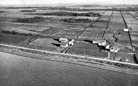
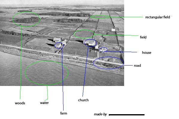
Activity 1: Analyzing a photo of a seigneury
45 minutes
Subject-specific competency: Understands the organization of a society in its territory
Cross-curricular competency: Cooperates with others
Teacher:
Students:
The students identify the various physical elements that are characteristic of seigneuries (e.g., houses, roads, fences, water, land, trees).
Teacher:
Using a T-chart (Click to create your own! ), the teacher and students define what is expected of students when working in pairs. (Keep the chart for future use.)
Students (in pairs):
On a sheet of paper, the students attempt to organize the various words in the mind map according to the method selected.
Example:
Human: houses, roads, fences
Natural: water, land, trees
Teacher:
Ask the students to keep their sheet of paper for future use.
Activity 2: What is a seigneury?
60 minutes
Other competency: Reads various texts
Teacher:
Introduce the primary source text.
First, the teacher can illustrate what a primary source text is by showing the students one of his/her own letters or drawings from when he/she was young.
The students read the text “A bird’s-eye view of a seigneury” Download individually and identify 6 to 10 words they don’t understand in the text. The teacher collects the difficult words identified by the students and develops a strategy to teach them vocabulary skills.
Students:
As a class: The students follow the appropriate steps before, during and after the reading of Jocelyne Giasson’s text entitled “Vocabulaire et mise en situation.” Download
In pairs: Based on the primary source text they have just read, the students add further information to their definitions of a seigneury using the sheet from activity 1.
As a class:
The teacher and students use those sheets to define subsets of a seigneury.
Example of possible subsets:
- Human: houses, roads, fences, barns, earthen ovens, woodstoves, parishes, cleared land, censitaires, seigneury, arpents
- Natural: water, land, trees, St. Lawrence River, Richelieu River, animals, standing timber
- People: censitaires
- Buildings: houses, barns, bread ovens, church
- Infrastructures: roads, parishes, seigneury
Teacher:
Write the students’ ideas on a flip chart (keep for future use). Seigneuries will be discussed in further detail during the next activity.
 Activity 3: Analyzing a photo using ICT (in the computer lab)
45 minutes for both partners to do their part
Cross-curricular competency: Uses information and communications technologies
The students analyze a photo using MS Paint or a vector graphics program. (Google Draw can also be used for this! Or even a photo localized inside Cartograf which has it’s own editor.)
To find out more about photo analysis, consult “Photo and image analysis” courtesy of the Service national du RÉCIT de l’univers social.
Click here ![]() for an example of a photo analysis done by two students.
for an example of a photo analysis done by two students.
Review of the situational problem
Why are more people living in cities today?
Teacher:
- What were roads made of at the time?
- What means of transportation were used on land and on water?
- How was the land ploughed?
- How were trees cut?
- How were houses built?
Draw parallels with today’s situation in order to clarify the initial question.
Step 4: A map of a seigneury
Have students define what a seigneury is using texts and a map.
Hook
20 minutes
Subject-specific competency: Understands the organization of a society in its territory
Seigneury game
The purpose of this game is for students to identify how the main elements characteristic of a seigneury were organized physically on the territory.
Seigneury game in PDF format Download
Tokens for the game in PDF format Download
Ask the students about the various components of the game: What is found on the game board? Keep track of their answers on a sheet of paper.
Key elements: people, seasons, buildings. The game board “squares” are actually rectangular and perpendicular to the waterway. The square for the seigneur’s estate is the largest, followed by the one for the parish church.
Activity 1: Reading texts
2 X 60 minutes
Other competency: Reads various texts
Teacher:
Demonstrate how to read and make notes using the “Clearing the land” text as an example. Download
Then distribute one of the following texts to each student (taking into account levels of difficulty):
Note: French texts are on RECITUS here
Students:
The students read the texts individually and make notes on their observation worksheets.
The students divide into teams based on the text they have read. The teacher asks them to:
- Discuss the important elements they have noted that are characteristic of seigneuries and how they are physically organized on the territory.
- Identify these elements on their maps of a seigneury.
Each team then presents its findings to the class.
Activity 2: Sketching a seigneury
30 minutes
Teacher:
Review what has been done so far: Based on the student presentations, the mind map, the flip chart page (“A bird’s-eye view”) and the game, identify with the students the elements that make up a seigneury:
- Waterway (river)
- Rectangular plots of land perpendicular to the river
- Censitaires’ buildings: houses, barns, bread ovens
- Seigneur’s buildings: manor house, mill
- Church dominating the seigneury
- Common land
- Cultivated land and standing timber (land that has not been cleared)
- Roads, etc.
Note there is a related Cartograf scenario entitled The Seigneurial System
Hand out a summary document to the students
Students:
In pairs: Using the summary document, the students are asked to sketch a seigneury.
Activity 3: Drawing a map of a seigneury (computer lab)
2 X 45 minutes
Cross-curricular competency: Uses information and communications technologies
Teacher:
Make sure to approve students’ sketches before they start this activity.
Students:
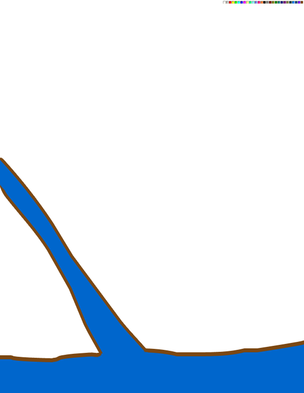
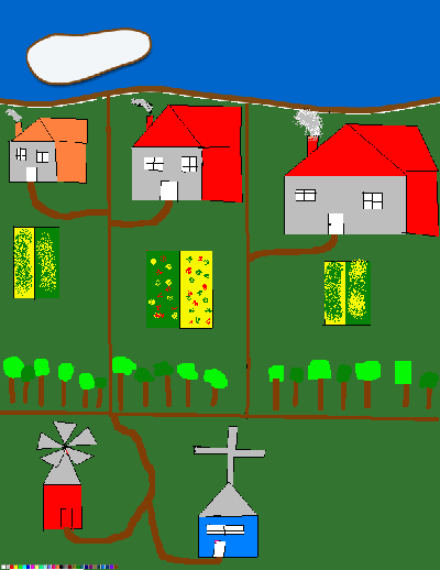
Once the sketches have been approved, the students draw a map of a seigneury using drawing software such as Paint. This activity can be done in pairs.
Student 1: Water, land, tree, road
Student 2: Buildings
The students can use the following images to create their maps. These six images can be put together (either by printing them out or viewing them on a webpage) to make a single image. Six seigneuries can then be drawn side by side, perpendicular to the river.
Example of the 6 images together (click to open and save)
1.  2.
2.  3.
3. 
4.  5.
5.  6.
6. 
Click ![]() for an example of a map of a seigneury created by two students.
for an example of a map of a seigneury created by two students.
Activity 4: Describing a seigneury
2 X 45 minutes
Other competency: Write various texts
Students:
While one student is using the computer, the other writes a text describing his/her seigneury.
Review of the situational problem
Why are more people living in cities today?
Teacher:
Ask the students:
- What has replaced the plough today?
- What has replaced mills?
- Do today’s farmers live entirely off their land?
- What means of transportation are used today to travel to the city?
—- Integration Phase —-
Step 5: Remnants of the seigneurial system
Have students identify the remnants of the seigneurial system in existence today.
Activity 1: Remnants of the seigneurial system
45 minutes
Subject-specific competency: Understands the organization of a society in its territory
Teacher:
Do remnants of the seigneurial system still exist today?
Help the students identify the remnants of the seigneurial system.
Use the PowerPoint document (photos, maps, etc.) to complete this activity.
“Remnants of the seigneurial system today” Powerpoint as PDF Download
Students:
Remnants of the seigneurial system in existence today include: Route 138 (the King’s Road), churches, rectangular plots of land, population concentrated along the banks of the St. Lawrence, the names of certain towns, houses, French-style manor houses, concession roads (rangs), etc.
Step 6: Technology today
Encourage students to examine the phenomenon of urbanization and its consequences for our relationship with the environment.
Broad areas of learning: Environmental Awareness and Consumer Rights and Responsibilities
Activity 1: How technology has changed our lives
45 minutes
Review of the situational problem
Why are more people living in cities today?
In New France, the proportion of people living in rural vs. urban areas was reversed compared to present-day Québec: 1 out of 5 people lived in urban areas (in a class of 25 students, this means 20 were living in rural areas vs. 5 in urban areas).
In developing countries such as Ethiopia in Africa, 80% of the population earns their living from agriculture.
Technological progress has changed the proportion of people living in urban vs. rural areas. For example, point out to students how easy it is to buy fresh fruits or vegetables at any time of the year.
Without refrigeration, how was food stored for long periods of time?
“Urban vs. rural populations” Powerpoint document in PDF format Download
Teacher
Remind the students of the urban/rural cards used at the beginning of this task. The proportion of people living in rural vs. urban areas is now reversed as compared to New France.
Students:
Have all the countries in the world experienced this change? Why are more people living in cities today?
Teacher:
Optional: Ask the students to identify the impact of technology and urbanization on our society.
Positive: Positive elements may vary.
Negative: With the concentration of the population in cities, the problem of pollution (air and water) is an important element to bring up.
Students:
What are the positive or negative consequences of scientific and technological progress on the phenomenon of urbanization?
Teacher:
Write the students’ ideas on the board.
Evaluation
Workbook
*Note to teachers
The student workbook is a tool intended for both students and teachers.
The students can use it to organize the concepts they are learning and keep track of their reflections in the context of a formative evaluation. Students are asked to evaluate their own progress and modify their approach accordingly throughout the learning and evaluation situation.
The student workbook is also an important tool for teachers, who can add notes and comments that will help steer students in the right direction. Teachers can also use the workbook as an evaluation tool to observe students’ progress.
It is therefore important to respect the goals of the student workbook and to present these goals to the students at the beginning of the learning and evaluation situation.
Student workbook in PDF format Download Seigneury LES_Student Workbook
Endnotes
- Barrie Bennett, Carol Rolheiser, Laurie Stevahn, Cooperative Learning: Where Heart Meets Mind (Toronto: Educational Connections), 1991, p. 124.
- 2. Lise Saint-Laurent et al., Programme d’intervention auprès des élèves à risque : une nouvelle option éducative [Intervention program for students at risk: A new educational option] (Montréal: Gaëtan Morin), 1995, p.105.
- Saint-Laurent et al., pp. 93-102.
This task was created by Steve Quirion, Bianca Ducceppe, Régine Gilles, Brigitte Coulombe, Dominique Lafrance and José Lecavalier. Graphic design and layout by Steve Quirion and Mathieu Rocheleau.
By www.recitus.qc.ca and adapted by LEARN in 2007